Community Bulletin
Twin Oaks Home Sales is now renting newly set-up manufactured homes at its Meadowlands community near Buckhannon — a quiet country setting close to town and schools. Good credit and references required; no homes are currently for sale at Meadowlands. Read more →
This story brought to you paywall-free, courtesy of the My Buckhannon team and our community partners
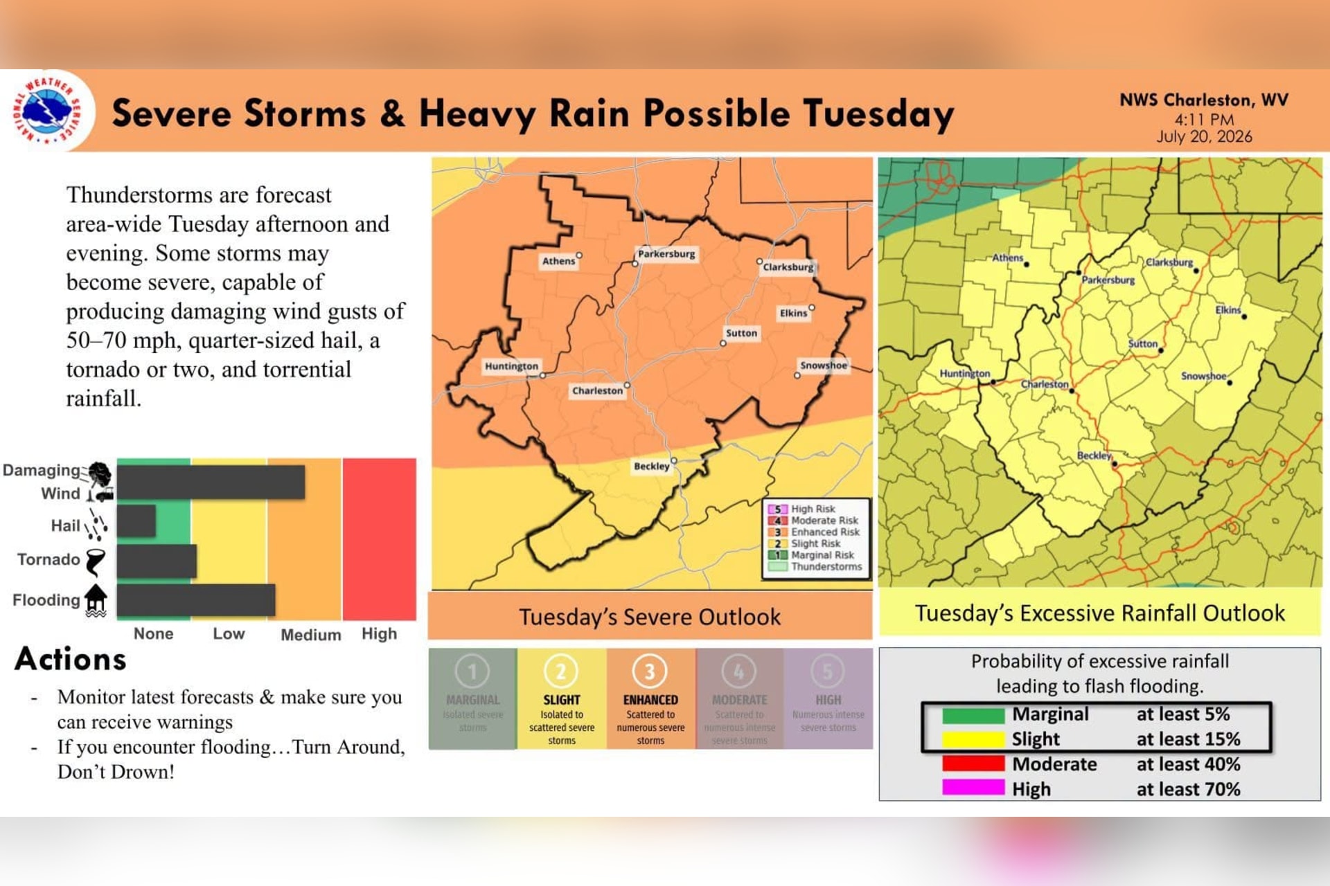
Upshur County could face severe thunderstorms Tuesday afternoon and evening as a strong cold front sweeps damaging winds, heavy rain and hail across West Virginia.
The National Weather Service office in Charleston said an “unseasonably strong wind field expected aloft lends confidence to impactful severe weather occurring Tuesday afternoon into Tuesday night.”
All severe hazards — wind, hail, tornadoes and flooding — are possible, forecasters said, but the primary threats are damaging wind gusts and heavy rainfall.
The Storm Prediction Center rates the threat of severe storms on a five-step scale, from a level 1 marginal risk at the low end to a level 5 high risk at the top. Its outlook for the region Tuesday is a level 3 “enhanced” risk, signaling that more numerous and stronger storms are possible.
Although enhanced risk falls only in the middle of the scale, it is an uncommon call for West Virginia, typically issued for the region only a few times a year.

Showers and thunderstorms are likely across the county before 3 p.m. Tuesday, with a brief lull possible between 3 and 5 p.m. before storms return in the evening. The high will reach about 82 degrees.
The greatest severe threat lines up with the afternoon and evening, as the cold front pushes in from the northwest. A line of storms is expected to move southeast ahead of the front, according to the weather service. In an update Monday, forecasters said storms could develop as early as noon and continue through Tuesday evening, though some uncertainty remains about the exact coverage and timing of the strongest storms.
Storms could continue past midnight. Rain is forecast before 2 a.m. Wednesday, and some of the overnight storms could drop heavy rainfall. Forecasters expect a quarter to a half inch of rain Tuesday, then another 1 to 2 inches Tuesday night.
The weather service said widespread storms Tuesday “may be severe and capable of producing damaging winds, hail, a tornado or two, and heavy rain.”
Wind is the main concern. Forecasters said gusts of 50 to 60 mph will be common, with isolated gusts approaching 70 mph possible. A few instances of large hail near quarter-size could also develop, and a tornado or two cannot be ruled out, most likely embedded within the line of storms rather than part of a stronger, isolated supercell.

“Torrential rainfall will be common with any severe storm,” the weather service said, though the flash flooding threat is expected to stay localized because the storms should keep moving quickly rather than stalling over one spot.
The City of Buckhannon urged residents to prepare while conditions are still calm. The city asked people to secure outdoor furniture and anything lightweight or not bolted down, and warned those in low-lying areas to be ready for fast-rising water.
“If you see flooding in the roadway, turn around. Do not drive through it,” the city said, noting that a vehicle’s waves can push water into homes and businesses. “We’re hoping for the best, but it’s important to be prepared for the worst.”
The city asked residents to call 911 in an emergency and to watch for watches and warnings from the Charleston weather office.
In its detailed forecast discussion Monday afternoon, the weather service described a weather system dropping out of Canada toward the Great Lakes that will drag a cold front toward West Virginia on Tuesday. That front is what sets the stage for the storms.

Ahead of it, hot and humid air will act as fuel. With temperatures climbing into the upper 80s and high humidity, forecasters expect the atmosphere to grow strongly unstable by afternoon.
One wild card is a cluster of storms — what forecasters call a mesoscale convective system, or MCS — expected to move out of the Midwest and into southeastern Ohio by Tuesday morning. Its leftover clouds and showers could work against the afternoon storms.
“Areas that are not affected by the remnant MCS for a prolonged period of time will have the greatest potential for airmass recovery, and there is particular interest across the southwestern zones where this may come to fruition,” the forecast discussion said.
If that happens, forecasters expect storms to line up along the front and organize quickly.
“Rapid storm development will be possible across the coal fields of northeastern Kentucky and into southwestern West Virginia, with storms forecast to unzip into another MCS that should become organized quickly due to the magnitude of large-scale forcing for ascent,” forecasters wrote.

Drier, milder weather is forecast to follow Wednesday through Friday, though valley fog is likely each morning once the front clears. Wednesday still carries a chance of showers and a thunderstorm, mainly before 2 p.m., with a high near 77 degrees.
Another round of storm chances could arrive over the weekend, but the weather service said the timing and coverage remain uncertain.
Residents can follow the latest watches, warnings and forecasts from the National Weather Service in Charleston.