Help Wanted
Central West Virginia Aging Services is hiring caregivers to serve elderly and disabled residents across the state. The nonprofit organization, which has been providing in-home services since 1974, has seven offices throughout West Virginia. Read more →
This story brought to you paywall-free, courtesy of the My Buckhannon team and our community partners
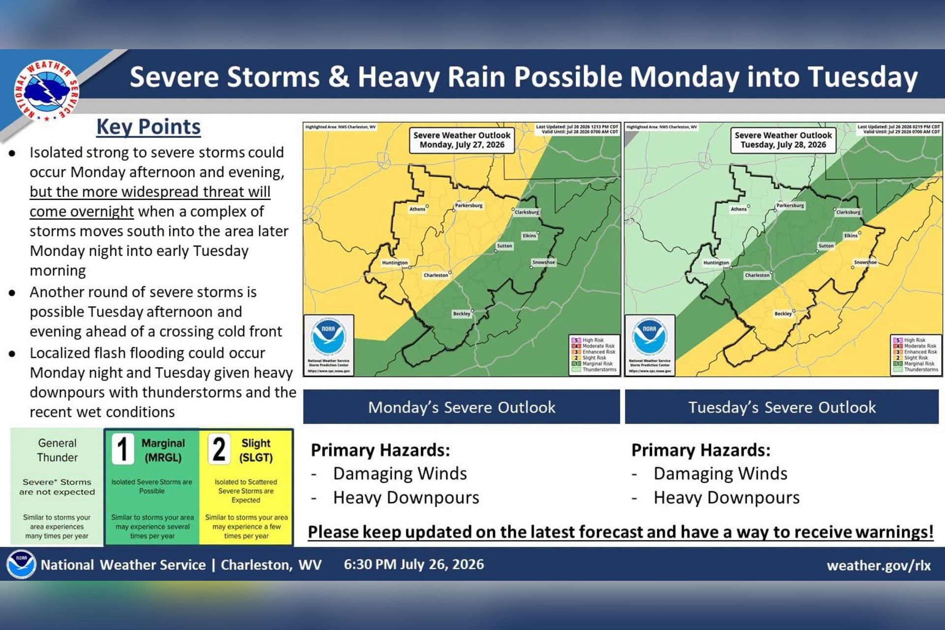
Two rounds of storms are expected to cross Upshur County tonight and Tuesday, but forecasters say damaging wind is the main concern and rainfall totals should stay under an inch — a fraction of what fell during last week’s catastrophic flooding.
“Complexes of storms are projected to arrive later this evening and cross through tonight,” the National Weather Service office in Charleston said Monday. “Damaging winds will be the main concern, but heavy rainfall could lead to localized instances of flash flooding.”
Forecasters are accounting for the state the ground is already in.
“Localized flash flooding could occur Monday night and Tuesday given heavy downpours with thunderstorms and the recent wet conditions,” the weather service said.
But the setup described for tonight and Tuesday is not the one that produced the July 21 disaster. The Storm Prediction Center rates the threat of severe storms on a five-step scale, from a level 1 marginal risk at the low end to a level 5 high risk at the top. Upshur County falls under a level 1 marginal risk Monday and sits near the western edge of a level 2 slight risk Tuesday, with the higher category covering eastern West Virginia.

The weather service describes a marginal risk as the kind of storms an area sees several times a year and a slight risk as a few times a year. Last week, by contrast, the outlook for the region was a level 3 enhanced risk — a call forecasters said typically comes only one to two times a year in West Virginia.
Isolated strong to severe storms could develop Monday afternoon and evening, the weather service said, “but the more widespread threat will come overnight when a complex of storms moves south into the area later Monday night into early Tuesday morning.”
The weather service said that first storms should reach Ohio, northeast Kentucky and western West Virginia between 6 and 9 p.m.
“The rest of the area will see this activity between 9 p.m. and 2 a.m. with heavy showers and storms continuing well into Tuesday morning,” forecasters said.
The Buckhannon forecast calls for scattered showers and thunderstorms between 2 and 3 a.m., then showers likely and possibly a thunderstorm after 3 a.m., with a low around 67 degrees and a 60% chance of rain.

Tuesday is expected to be the wetter day. Scattered showers and thunderstorms are forecast before noon, showers and a possible thunderstorm from noon to 4 p.m., then scattered showers and storms again after 4 p.m. The high will reach near 79 degrees, with southwest winds of 11 to 14 mph gusting as high as 25 mph and a 70% chance of rain.
Showers are likely again Tuesday evening before tapering overnight, with a low around 61.
Forecasters are predicting a tenth to a quarter inch of rain overnight, a quarter to a half inch Tuesday and less than a tenth of an inch Tuesday night — with the caveat that higher amounts are possible in thunderstorms.
For comparison, the storm that hit Buckhannon around 5 p.m. on July 21 dropped 3 to 5 inches of rain in about an hour, according to the weather service. The NWS measured 7.6 inches in parts of Upshur County over the 24-hour period, and most of that fell in a matter of hours.
The Buckhannon River crested at 27.59 feet, its highest in decades, and a gauge near Sand Run topped out at 10.63 feet, breaking a record set in 1985. The flooding killed two Upshur County residents and destroyed at least 33 homes in Upshur and Lewis counties.

For the main threats Tuesday, wind leads the list. The weather service said the storms tracking through Monday night and Tuesday morning “may contain gusty/damaging wind gusts and heavy rain,” and that any severe storms could produce damaging gusts as the line organizes.
Flooding is also a concern, with the NWS noting that even fast-moving storms can dump water faster than the ground can take it.
“Although this activity should be fairly progressive given the forcing, rainfall rates exceeding 1 to 2 inches per hour could trigger rapid basin response and localized flash flooding,” the weather service said in its Monday morning forecast discussion.
Another round of severe storms is possible Tuesday afternoon and evening ahead of the crossing cold front, though that depends on whether the atmosphere recovers behind the morning storms. If those clear out fast enough to allow three to five hours of sunshine, the atmosphere could destabilize ahead of a cold front.
“Considerable forecast uncertainty exists for Tuesday afternoon, as severe potential remains highly contingent on morning convective clearing and thermodynamic recovery,” the weather service said.

In its Monday morning discussion, the weather service placed the most serious conditional threat across the southern coalfields, well south of Upshur County.
“Please keep updated on the latest forecast and have a way to receive warnings,” the weather service said.
After the cold front exits the state Tuesday night, the weather service expects a noticeably drier stretch behind it.
“Drier and quieter weather returns Wednesday through Friday with seasonable temperatures, though periods of hazy skies are expected due to western US and Canadian wildfire smoke,” forecasters said.
Highs settle near 76 degrees Wednesday, 77 Thursday and 81 Friday, with overnight lows in the upper 50s. Storm chances return over the weekend, building to a 50% chance of showers and thunderstorms Sunday.