Help Wanted
Sam's Pizza, a family-owned fixture in Upshur County since 1991, is adding delivery drivers to its team of more than two dozen at its Buckhannon location. Applicants are asked to apply in person at 9 Southfork Plaza Drive. Read more →
This story brought to you paywall-free, courtesy of the My Buckhannon team and our community partners
For a community still recovering from devastating flooding three weeks ago, the forecast over the next few days could trigger unpleasant memories.
But while several days of stormy weather are expected, even four or five inches of rain spread out over a week is a far cry from the seven inches Mother Nature dumped on Upshur and Lewis counties in one evening on July 21.
The National Weather Service office in Charleston has issued a flood watch through Friday morning that covers Upshur, Lewis, Barbour, Harrison and Randolph counties along with most of central and southern West Virginia, plus parts of southeast Ohio, northeast Kentucky and southwest Virginia.
“Flash flooding caused by excessive rainfall is possible,” the watch said.
The weather system arrives three weeks after the July 21 flood that killed two Upshur County residents, destroyed homes in Upshur and Lewis counties and pushed the Buckhannon River to 27.59 feet, its highest crest in decades. A gauge near Sand Run topped out at 10.63 feet that night, breaking a record set in 1985.

This week’s setup is different. Instead of a single storm parked over the hills, forecasters are tracking a procession of storm complexes rolling southeast across the region, one behind another, from Monday afternoon into Thursday.
“A series of systems are expected to traverse the area, each bringing potential for heavy downpours and training storms which may cause flooding,” the NWS said.
The repetition is what concerns forecasters. Summer vegetation and the breaks between storms should let the ground absorb a moderate soaking, according to the weather service’s Monday afternoon forecast discussion, but each round leaves less room for the next.
“Substantial flash flooding is possible early Tuesday through Thursday night across southeast Ohio, central West Virginia, northeast Kentucky, and the southern coalfields as repetitive convective complexes move through the region,” the weather service said.
Forecasters were careful to say the multi-day event could be less severe than predicted, if it even develops.

“It is important to note that this scenario is not guaranteed to be widespread or even occur at all, but this setup does leave the potential open to locally extreme flash flooding impacts,” the NWS scientists said in the afternoon discussion.
In Buckhannon, showers and thunderstorms are likely Monday night, with three-quarters of an inch to an inch of rain possible and a low around 67 degrees.
Tuesday brings a 70% chance of rain, a high near 82 and another quarter to half inch. Tuesday night is the wet one — a 100% chance of precipitation, a low around 65 and 1 to 2 inches of new rainfall, with the forecast noting that some of the storms could produce heavy downpours.
Wednesday and Thursday each carry rain chances between 60% and 70% and highs in the low 80s. Friday stays unsettled, with showers likely and a high near 80.
The National Weather Service’s Weather Prediction Center has singled out Tuesday as the day to watch.

“In coordination with WPC, a Day 2 Moderate Risk for Excessive Rainfall has been placed over much of southeast Ohio and central West Virginia for Tuesday,” the discussion said.
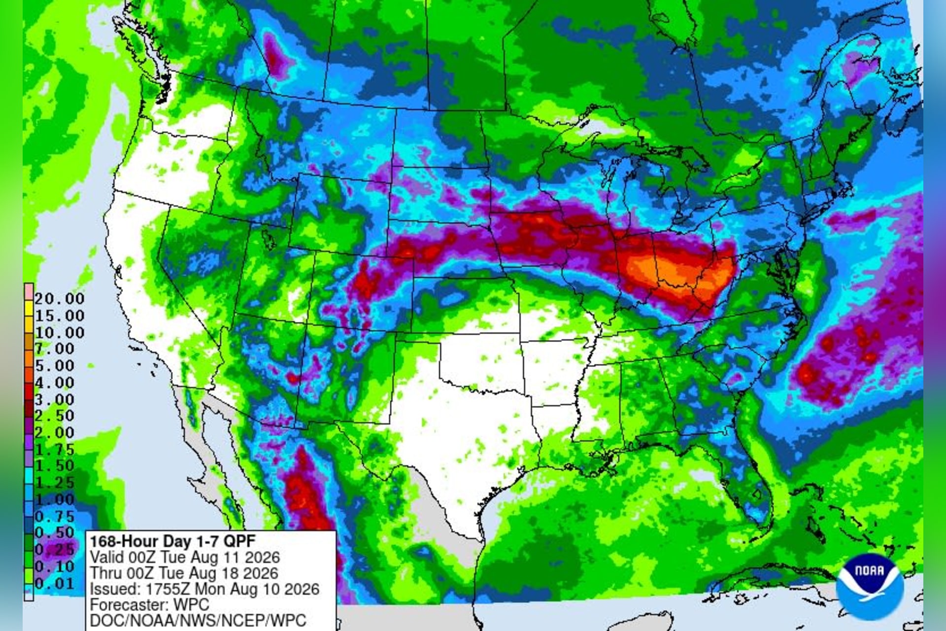
The same center’s seven-day rainfall forecast, issued Monday afternoon, puts 4 to 5 inches over parts of north-central West Virginia for the week beginning Monday evening. The map draws that rain as a large band running from the Plains across the Ohio Valley, with West Virginia at the eastern end.
River flooding is also a danger.
“Multi-day cumulative precipitation totals of 3 to 6 inches across larger river basins will drive significant rises, which could lead to river flooding, especially downstream of any localized extreme rainfall totals,” the NWS said.
The Buckhannon River started the week at a moderate level after a wetter-than-normal few weeks. The U.S. Geological Survey gauge in Buckhannon read just over 5 feet Monday afternoon, nearly 18 feet below the level where minor flooding begins. It had been falling since Saturday, when it peaked near 7 feet, and began ticking up again in the middle of the afternoon as the rains started.

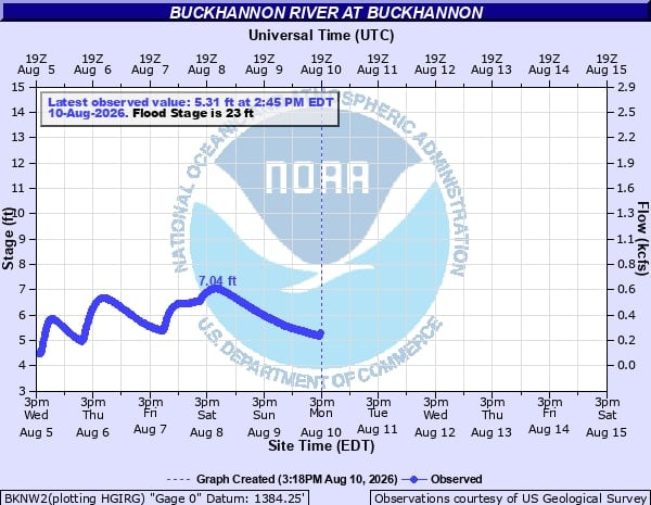
The weather service sets an action stage of 21 feet on the Buckhannon gauge, minor flood stage at 23 feet, moderate at 25 and major at 26. The river crested at 27.59 feet on July 21.
The National Weather Service advised folks to be ready for flooding, especially if it comes at night.
“The threat is heightened during overnight hours when flash flooding is hardest to detect and react to,” the discussion said. “Multiple rounds of severe thunderstorms capable of producing primarily damaging wind gusts are possible this evening through Wednesday/Thursday evening.”
Wet ground and full summer foliage lower the bar for wind damage in the mountains, according to the discussion. Gusts of 40 to 50 mph — short of severe criteria — can uproot trees and bring down power lines when they hold for several minutes.
The pattern is expected to let up at the end of the week. Friday night carries only a 30% chance of showers before 2 a.m. Saturday turns partly sunny with a high near 82, and rain chances build again Sunday.

Until then, a watch is not a warning. It simply means the ingredients for severe weather are in place.
“You should monitor later forecasts and be prepared to take action should Flash Flood Warnings be issued,” the NWS said. “Residents in hollows, floodplains, and low-lying terrain should have multiple ways to receive warnings and have a plan of action to move to higher ground this week if conditions warrant.”
“If you live in a flood-prone location, be prepared to seek higher ground should flood waters start to encroach,” the NWS Charleston office added. “Be especially vigilant when driving, as water depth can be difficult to estimate. Turn around, don’t drown.”