A winter storm is expected to bring heavy snow, freezing rain and dangerous cold to Upshur County starting Saturday, prompting Governor Patrick Morrisey to urge West Virginians to prepare now.
A Winter Storm Warning is in effect for Upshur County and much of the region from 7 a.m. Saturday to 7 a.m. Monday, according to the National Weather Service.
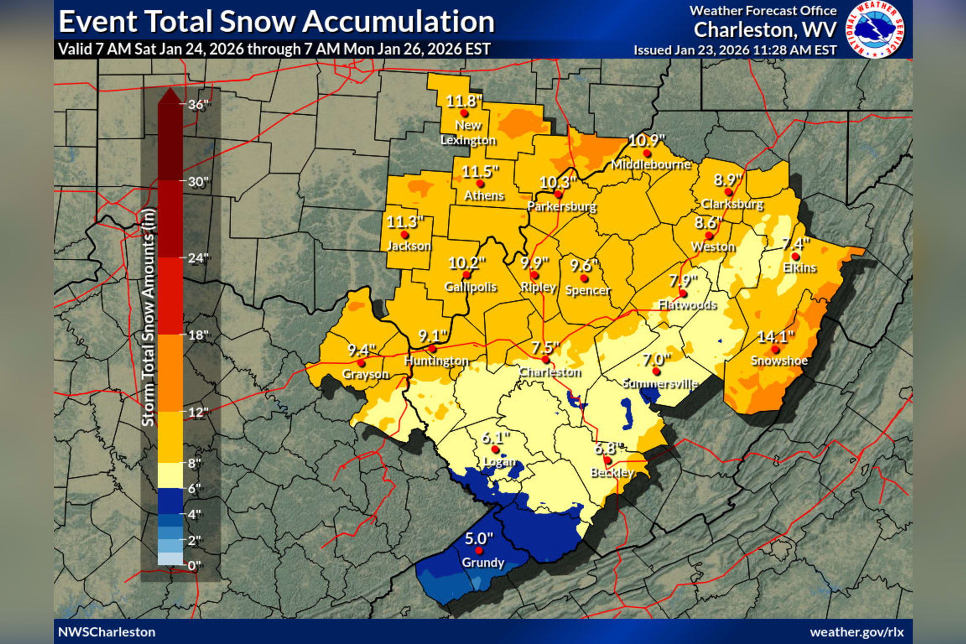
“Heavy mixed precipitation expected. Total snow accumulations between 9 and 12 inches and ice accumulations around two-tenths of an inch,” the NWS warned. “Travel could be very difficult to impossible. The hazardous conditions could impact the Monday morning commute.”
Before the snow arrives, a Cold Weather Advisory is in effect from 8 p.m. Friday to 10 a.m. Saturday. The NWS warned of “very cold wind chills as low as 10 below” that “could result in hypothermia if precautions are not taken.”

Friday night will be partly cloudy with a low around 3 degrees. Saturday will see increasing clouds with a high near 21 degrees before snow begins Saturday night.
According to the NWS extended forecast for Buckhannon, Saturday night will bring “snow before 4 a.m., then snow, possibly mixed with freezing rain. The snow could be heavy at times.” Snow accumulation of 3 to 7 inches is possible Saturday night alone.
Sunday will bring a wintry mix — snow and freezing rain before 1 p.m., then rain and freezing rain possibly mixed with snow through the afternoon, with an additional inch of snow possible. The high will reach 35 degrees.
Snow continues Sunday night into Monday, with snow likely through Monday afternoon and a high of only 18 degrees. Monday night’s low drops to a single degree above zero.

Forecasters noted some uncertainty remains as warm air aloft — sometimes called a “warm nose” — pushes into the region. According to the NWS forecast discussion, “snow amounts have decreased slightly and ice accumulations have increased slightly, which accounts for more mixed precipitation expected as the warm nose gets further into the area.”
The NWS said snowfall totals “may decrease in values as we get closer to the event and as the warm air aloft is forecast to dig in deeper across the lowlands” from Saturday night through most of Sunday. However, the agency emphasized “this does not affect impacts which will be moderate to significant across the entire area.”
Morrisey held a briefing Friday outlining the state’s preparations.
“While the forecasts may change, we want to make sure we are prepared to work together to keep our people safe,” Morrisey said, according to a press release from his office.
Deputy Director of Emergency Management Matthew Blackwood provided guidance for residents.
“This is about our response as a government, but also about the need for neighbors to look out for neighbors and plan ahead,” Blackwood said.
The governor’s office recommends residents review emergency supplies, including food, water, medications, flashlights, batteries and blankets. Residents should fully charge cell phones and backup power supplies, avoid unnecessary travel once conditions worsen, and check on family members, neighbors and anyone who may need assistance, especially older adults and those with medical needs.
During and after the storm, travel should be limited to essential trips only. The governor’s office warned that generators must be operated outside, at least 20 feet away from homes, and grills or fuel-burning devices should never be operated indoors.

“Ice accumulations will become significant throughout the event,” the NWS said. “This will lead to significant impacts to power outages as heavier wet snow mixes in along with ice accumulations.”
For power outages, residents can contact Mon Power at 1-800-686-0022, AEP at 1-800-956-4237, or Potomac Edison at 1-800-686-0011. Those needing access to a warming center or food bank can call 211. For emergencies, call 911.
The NWS noted that once this system exits Monday, “colder Arctic air will infiltrate” the region, with more cold weather expected through midweek and beyond.