Community Bulletin
WVU Medicine St. Joseph's Hospital's Center for Women's Health has opened its 2026 prenatal and pregnancy classes — including Spinning Babies, breastfeeding basics and Lamaze — for expecting Upshur County families, with Lamaze offered in person or online. Read more →
This story brought to you paywall-free, courtesy of the My Buckhannon team and our community partners
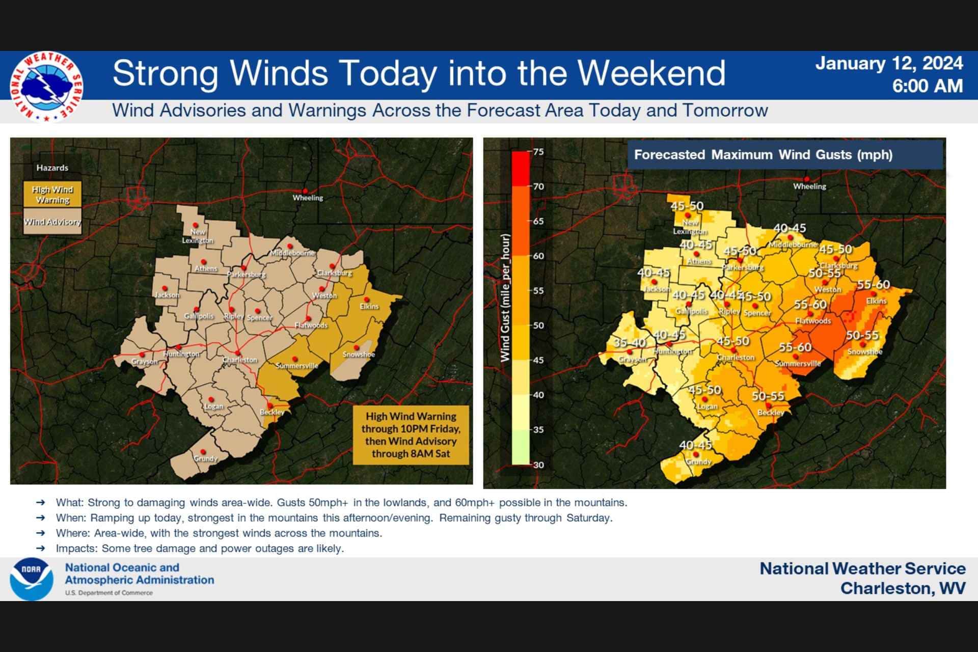
CHARLESTON — An unsettled weather pattern will affect much of West Virginia over the next several days as high winds and rain will transition to snow and finally frigid cold.
“Dry weather can be expected through [Friday] morning, although winds will increase and start to become gusty, especially across the mountains, as another potent system approaches,” the National Weather Service’s office in Charleston noted in a Friday morning weather briefing. “This system brings rain and strong gusty winds from the south to southeast throughout the area this afternoon and evening, the wind strongest in and near the mountains.”
Rain and snow are expected later Friday.
“The cold front associated with this system will then whip east across the area tonight, providing a transition to snow showers,” the NWS said. “Accumulations of 1 to 3 inches are possible in the mountains from overnight tonight into Sunday morning. Another system is expected Sunday and Monday, with chances for snow area wide through Tuesday. Turning frigid next week.”
![[MYB] [2026-02-10] Job Listings Page](https://res.cloudinary.com/mytown/image/upload/f_auto,q_auto,c_limit,w_540/spotlights/qd9sdo6tvhl5jxea4z8u)
Upshur County is under a high wind warning on Friday with southeast winds of 25 to 35 mph and gusts of up to 60 mph possible.
“Damaging winds will blow down trees and power lines,” the warning notes. “Widespread power outages are expected. Travel will be difficult, especially for high profile vehicles.”
The NWS advises residents to use caution.
“People should avoid being outside in forested areas and around trees and branches,” the NWS warns. “If possible, remain in the lower levels of your home during the windstorm, and avoid windows. Use caution if you must drive.”
![[FMG] [2026-02-02] Emergency Weather Repairs 2](https://res.cloudinary.com/mytown/image/upload/f_auto,q_auto,c_limit,w_540/spotlights/y2ocqu3yood0lor1cixh)
The transition from rain to snow could also cause travel difficulties.
“Rain changing to snow overnight tonight [will create] slick travel in spots,” according to the NWS hazardous weather outlook. “Use caution if traveling. Light accumulations expected.”
Gusty winds will remain through the weekend, with more snow and even colder temperatures expected early next week.
“Strong gusty winds will impact the area Saturday and Sunday,” the NWS forecasts. “Wind gusts up to 55 MPH are possible. Another disturbance could bring light snow accumulations to the area Monday and Tuesday. Frigid temperatures expected Monday through Wednesday associated with an arctic air mass. Dangerous wind chills could be possible Tuesday and Wednesday across elevations above 3,500 feet.”
![[DHS] [2025-05-23] Primary Care](https://res.cloudinary.com/mytown/image/upload/f_auto,q_auto,c_limit,w_540/spotlights/uxjgdvofnhnwtmbb9ap7)
The forecast currently calls for high temperatures in the mid-20s and lows in the teens Sunday and Monday. Tuesday night is expected to be the coldest night, with a low of just 5 degrees.
![[AGING] [2024-12-13] In-Home Services](https://res.cloudinary.com/mytown/image/upload/f_auto,q_auto,c_limit,w_540/spotlights/ropbl44m1kd43zhrw1fu)
![[HANK] [2026-01-23] Rate Lock](https://res.cloudinary.com/mytown/image/upload/f_auto,q_auto,c_limit,w_540/spotlights/dmqkcxthbuh8978vmbue)