Community Bulletin
For more than 120 years, the Elkins hospital now known as Davis Medical Center has been where the Potomac Highlands turns for care. Today that includes expert kidney care close to home — sparing many patients a drive out of the region. Read more →
This story brought to you paywall-free, courtesy of the My Buckhannon team and our community partners
UPDATE: The National Weather Service has now issued a winter weather advisory in addition to a wind advisory.
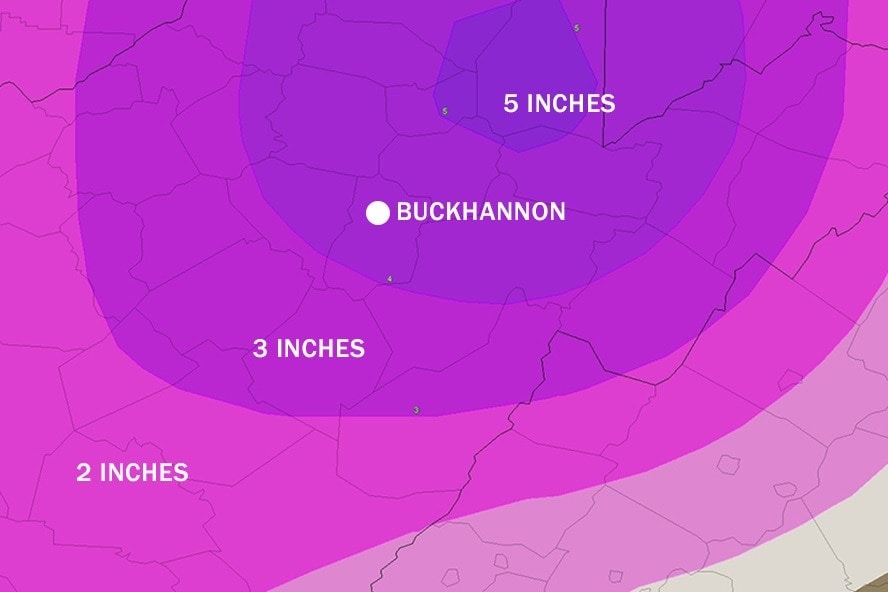
“Snow expected. Total snow accumulations of 3 to 5 inches,” reads the winter weather advisory, which is in effect from 7 a.m. Wednesday morning to 7 a.m. Thursday. “Locally higher amounts, reduced visibility, and briefly strong wind gusts may occur if snow squalls develop on Wednesday.”
The advisory warns travel will be hazardous.
“Travel could be very difficult,” according to the NWS. “The hazardous conditions could impact the morning or evening commute.
![[HANK] [2026-01-23] Rate Lock](https://res.cloudinary.com/mytown/image/upload/f_auto,q_auto,c_limit,w_540/spotlights/dmqkcxthbuh8978vmbue)
“A winter weather advisory for snow means periods of snow will cause primarily travel difficulties. Expect snow covered roads and limited visibilities, and use caution while driving.”

Original story:
The National Weather Service issued a wind advisory Tuesday morning for Upshur County, saying a cold front moving through the area could bring sustained winds with gusts up to 45 mph.
![[FETC] [2025-08-23] Earn a CDL 1](https://res.cloudinary.com/mytown/image/upload/f_auto,q_auto,c_limit,w_540/spotlights/chkiaoujerahxlckcnql)
As temperatures rapidly drop, snow is then forecast to develop and persist through Thursday.
Sustained winds from the west of 20-30 mph are expected, with gusts up to 45 mph, according to the advisory, which runs from 5 p.m. Tuesday to 1 a.m. Wednesday. The strongest winds will begin in the late afternoon and last through the evening.
“Gusty winds will blow around unsecured objects,” the advisory reads. “Tree limbs could be blown down and a few power outages may result.”
The National Weather Service also says drivers need to use caution while traveling.
![[AGING] [2024-12-13] In-Home Services](https://res.cloudinary.com/mytown/image/upload/f_auto,q_auto,c_limit,w_540/spotlights/ropbl44m1kd43zhrw1fu)
“Winds this strong can make driving difficult, especially for high profile vehicles,” the NWS warns. “Use extra caution.”
A hazardous weather outlook from the weather service says snow is expected Wednesday and Thursday.
“Snow squalls will be possible Wednesday into early Thursday,” according to the outlook.
“Heavy squalls could make travel hazardous during the Wednesday afternoon commute and roads could remain slick through Thursday morning as temperatures fall well below freezing. A winter weather advisory may be needed at a later time.”
Temperatures are expected to peak near 60 degrees today but plummet to a high of just 30 Wednesday.
![[CHAMBER] [2026-06-23] Hiring Executive Director](https://res.cloudinary.com/mytown/image/upload/f_auto,q_auto,c_limit,w_540/spotlights/jqvoqa1wl63oqmzrnmeg)
Another storm system could form later this weekend. Two low pressure systems are currently expected to track north and south of West Virginia. However, is those systems were to merge, the Mountain State could be in for a snow event on Saturday and Sunday.
![[DHS] [2025-05-23] Primary Care](https://res.cloudinary.com/mytown/image/upload/f_auto,q_auto,c_limit,w_540/spotlights/uxjgdvofnhnwtmbb9ap7)
![[FMG] [2026-02-02] Emergency Weather Repairs 2](https://res.cloudinary.com/mytown/image/upload/f_auto,q_auto,c_limit,w_540/spotlights/y2ocqu3yood0lor1cixh)